


2024-5-17 marche 11 Espinosa del Camino -Atapuerca

Christianlabourie
User
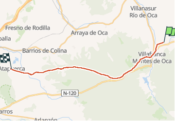

Length
22 km

Max alt
1158 m

Uphill gradient
338 m
Km-Effort
26 km

Min alt
921 m

Downhill gradient
317 m
Boucle
No
Creation date :
2024-05-17 05:55:03.222
Updated on :
2024-05-17 10:52:14.429
4h54
Difficulty : Very difficult

FREE GPS app for hiking
 SityTrail
IGN / Geographical institutes
SityTrail Plus
The world is yours!
About
Trail Walking of 22 km to be discovered at Castile and León, Unknown, Espinosa del Camino. This trail is proposed by Christianlabourie.
Positioning
Country:
Spain
Region :
Castile and León
Department/Province :
Unknown
Municipality :
Espinosa del Camino
Location:
Unknown
Start:(Dec)
Start:(UTM)
476012 ; 4694670 (30T) N.
Comments